|
| |
Evolution Encyclopedia Vol. 3 Chapter 26 PALEOMAGNETISM
CHAPTER 26 - PALEOMAGNETISM BASIC ARRANGEMENT OP THIS CHAPTER Introduction Evidences for plate tectonics 1 - Continental drift theory 2 - Major faults Paeleomagnetism 1 - Earth's magnetic field 2 - Magnetic properties of rocks 3 - Wandering poles 4 - Earth's fluid core 5 - Polar movement 6 - Magnetic reversals 7 - The geomagnetic core 8 - Potassium-argon dating 9 - Ocean floor evidence 10 - Volcanic evidence 11 - Conclusion Appendices 1 - Continental drift and plate tectonics 2 - Magnetic reversals 3 - Potassium-argon dating 4 - Ocean core dating Related studies: Chapter 5, Origin of the Earth Chapter 6, Age of the Earth Chapter 7, Dating Methods Chapter 17, Fossils and Strata Chapter 19, Effects of the Flood New words are being heard in scientific circles: Plate tectonics, continental drift, wandering poles, Paleomagnetism, seafloor spreading, field reversals, and transforming faults. What does it all mean? How does it relate to the creation—evolution controversy? Is part or all of it true? Does any portion of it prove evolution? In this chapter we will briefly survey this broad topic which, suddenly in the 1960s, became accepted as the majority view of various geological and oceanographic scientists. In the first section, we will consider the various lines of evidence that led up to a general acceptance of plate tectonics, and what is involved. In the second section, we will briefly focus on the principle concern: Paleomagnetism and its "paleomagnetic dating" implications. Please keep in mind that this chapter is actually an extension of chapter 19, Effects of the Flood. A review of that chapter will better help you understand the material in this present one.
CONTINENTS WERE ONCE LINKED—Evolutionists declare that at some earlier time in earth history the continents were all joined together. Citing certain evidence which they believe indicates this, they have decided that the continents moved into their present locations from a mythical, single massive continent. This theory is called "continental drift."
Three possible evidences for this theory are explained below, each of which can be explained just as easily by events prior to, during, and immediately following the Flood. In addition, there is also evidence which is specifically opposed to the moving continent theory. 1 - Continental match. The outstanding evidence for continental drift is the manner in which the coastal outline of eastern South America appears to somewhat match that of the west coast of Africa. Other continental outline matches have also been devised, but, as a rule, they require greater stretches of the imagination to work out. Continental match may not sound like very outstanding scientific evidence, especially since continents have to be twisted around a bit to make them even partly match. But this remains one of the best evidences that the continental drift advocates have to offer. CONTINENTAL DRIFT Illustrated below is the floating continent theory. It is foolish to begin with, to imagine that granite continents move hers and there and change shape as they go. But, not content with the ridiculous, evolutionists speculate that they can decipher exactly how continents formed and reformed, moved and removed for millions upon millions of years in the past—and then be able to tell what position those continents were in at various periods so many millions of years ago! Foolish theories, once begun, have a way of gradually growing into fantastic dream worlds. Reason seems to have been abandoned and desperation takes its place. The recipe for atheistic assurance has come to be complex theories, strange new names, and the dating of imagined events far into the past. \\
Flood geology can explain continental match quit adequately—and without having to resort to far-fetched ideas of continents traveling sideways thousands of miles! Prior to the Flood there were only broad rivers and shallow seas. The continents were close together and joined at that earlier time, except for shallow, river—like, narrow seas which may have been between them. As the seas filled and continents rose, some of these original outlines may have remained in match—just as the two sides of a river will match in outline. Matching of continental borders has been a primary reason why continental drift was initially accepted by scientists. But *Corliss explains that the "matching coastlines" proof is no proof at all.
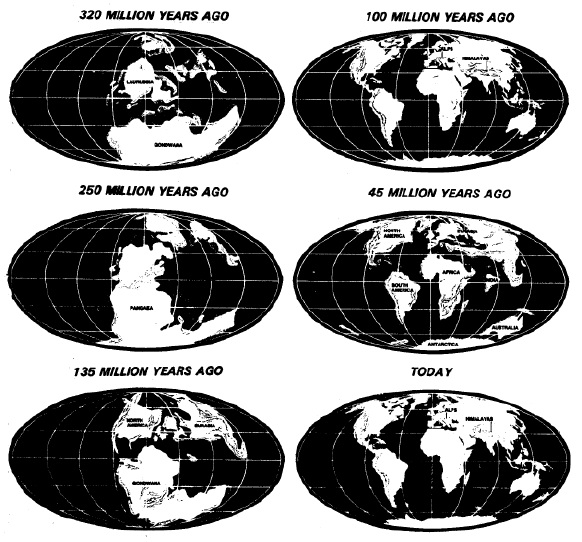
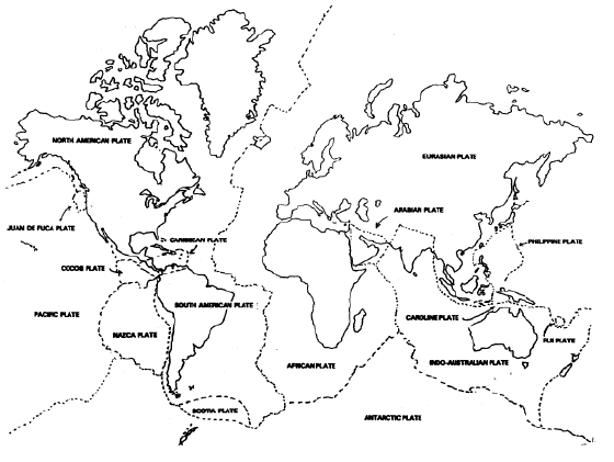
2 - Fossil match. It has been observed that some fossils in Antarctica match the type of fossil plants and animals found in the southern continents—South America and Africa, and in North America, Arctic, and Siberian region. This fact of similar animals on nearby continents theoretically could support either view (Flood geology or moving continents), yet Flood geology would only take us back a few thousand years for fossil remains of similar animals; whereas continental drift would require millions of years to bring us back to a time when plants and animals were on both continents. At the beginning of the Flood, a uniformly warm climate would have produced the floral and faunal similarities noted today in fossil remains. 3 - Vegetation and mineral match. Similar vegetation has been found on the east coast of South America and the west coast of Africa. This is said to be one of the strongest evidences of continental drift. In addition, in some cases there are similar minerals. For example, the small and inconsequential diamond fields in northern South America and the large diamond mines in South Africa are thought to be strong evidence that the two continents were once joined. But, in reality, these facts would support either view. Either view would recognize a prior partial or total uniting of South America and Africa. Hence the similarity of plants and minerals on different continents. However, later predation and climatic changes could affect which animals would survive on which continents, thus explaining why there now is different animal life in South America, Africa, Australia, etc. (See chapter 27, Geographic Distribution.) According to evolutionary theory, vegetation has continually evolved. According to continental drift theory, the continents separated millions of years ago. How then can there be similar vegetation on those separated continents today? MAJOR FAULTS—It is well known that there are major fault lines on the globe. These fault lines are the cause of the "ring of fire" faults which produce the volcanoes that surround the Pacific area. Plate tectonics teaches that these cracks are caused by gigantic plates which are sliding beneath each other. In contrast, Flood geology would suggest that when the continents rose and ocean basins sank during and shortly after the Flood, the immense stress placed on the underlying foundations produced these geologic fault lines. The problem here is "geostasy," or the balancing of massive areas of the earth. As one part goes down, another part must move up to equalize or balance the load. An example of this would be the oceanic "trenches," which are the deepest places in the oceans. These narrow canyon—like depths always match corresponding curved island groups produced by volcanoes bringing magma up from deeper areas. It was the volcanic ejections which produced the nearby trenches. Present-day tsunamis (seismic or "tidal" waves) frequently originate from adjusting movements in those trenches. Another example of these global cracks would be the Mid-Atlantic Ridge which runs down the North and South Atlantic Ocean, and the fault line in its center. Small amounts of hot lava issue forth from that fault line. Plate tectonics claims that this small amount of lava has produced "sea floor spreading, " a theoretical sideways push which earlier separated the American continents from Europe and Africa. But careful examination reveals only a very small amount of lava flowing out of that Mid-Atlantic crack. In reality, instead of pushing the continents sideways, earlier lava flows built up the Mid-Atlantic Ridge, for, on both sides of this central crack, is a high-walled volcanic pile of igneous rock. The extruded lava produced that twin mountain range in the middle of the North and South Atlantic. It was the lava flow which produced these high piles of lava; not a sideways pushing of the entire sea floor sideways for thousands of miles! Two other examples of major fault areas would be the Great Rift Valley that runs from the Red Sea down through eastern Africa, and the San Andreas Faun in California. But in both instances there is no evidence that theoretical massive sideways movements are now occurring, such as are claimed to have produced all the oceans, containing as they do five-sixths of the area of earth's surface! These "subduction" zones are definitely not producing the large sideways movement predicted by plate tectonic theory. It is not enough to say that, "given enough time, it could have happened." In chapter 6, Age of the Earth, we learned that the earth cannot be over 6,000-10,000 years old! Item after item of evidence points to this fact, negating the possibility of long ages of earth prehistory. In chapter 7, Dating Methods, we learned that not one method used to provide evolutionists with long prehistory dating has ever proved reliable! Each one of them is subject to a number of serious flaws, any one of which would ruin the predictability of their clocks. 1- Plate tectonic explanation of continental shape. Along with those of Paleomagnetism, certain findings in the 1960s resulted in the acceptance of an overarching theory, known as "plate tectonics," which is breathtaking in scope. According to this theory, massive plates are continually moving sideways. Each plate is a piece of earth's crust, several hundred miles thick and generally thousands of miles in length and width. Each plate is theorized to be moving horizontally. Where one plate meets another, its thousands-of-feet thick, solid rock gently "bends" at a sharp angle and moves downward through solid rock! This is said to result in theorized sea floor spreading, and continental drift. The latter would better be termed "continental travel," and is the wandering apart of all the continents of the globe from two original continents (the larger "Gondwana," and the smaller "Laurentia") which are said to have existed 320 million years ago, later becoming "Pangaea" in the "Tethys Sea," 250 million years ago; and still later journeying into the present positions and shapes of all our continents. PLATE TECTONICS The chart below will provide you with a brief overview of plate tectonics. Uncertainty and confusion as to the location of some of the plates continues on up to the present. Earthquake data reveals that there definitely are several major cracks in Planet Earth (running around the Pacific, through the Mediterranean, etc.). But the existence of such cracks does not support the peculiar "boiling water" theory of rotating plates theory which currently enraptures geologists.
2 - Alternate explanation of continental shape. We have already mentioned the pre-Flood factors of closely-connected continental masses, and rising waters between them during the deluge. Another reason for the present shape of the continents would be the wearing, depositing action of water and ice, and the balancing of geostasy, by which one land mass would rise to compensate for another that had lowered. Our present continental shapes are the result, not of traveling land masses, but of hydraulic effects of the Genesis Flood. One indication of this is the very similarity of continental shapes—of South America, Africa, Australia, Greenland, for example. Consider the following: With a world map open before you, note that the lower right side angles downward toward the left (west), and the bottom is somewhat pointed. The upper left of that continent bulges out somewhat, and the top tends to be flattened, angling toward that bulge in the upper left. Off the coast, on the lower right, are some islands. Now compare it with Africa and Australia and note the decided similarities! Even the coastline of India matches those southern-half features. Look at Greenland. Why are all these so similar? It may be due to the immense turbulence and water movements during the Flood. In the northern hemisphere, glacial action produced decided effects also. The close similarity of these shapes indicates that their outlines were molded by water action, not by random movements of continental masses. Now took at the northern hemisphere continents (North America and Eurasia). Note how they protrude out to the left and right at their upper corners. So much water is found in the lower southern hemisphere that the Antarctic continent rose to offset it (geostasy, or geostatic balance it is called). At the top of the world, we find the opposite situation. The Arctic sunk, and the continental masses south of it consistently have extra wide bulges to the upper right and left. Now consider the center of the map. Here we find a distinct pattern tending towards a worldwide east-to-west waterway: The Gulf of Mexico, the Mediterranean Sea, and the Indian Ocean. Why is that waterway there? Perhaps it was placed there by a prearranged plan of a master Designer. If it had not been there, most of North America, Central America, southern Europe, and India to China would be as dry and rainless as the Sahara. Glaciers coming down from the Arctic damaged the northern part of North America, Greenland and Eurasia, producing islands, fords, and bays. Lacking those glaciers, those northern borders would have been as smooth as the northern part of South America. No one has all the answers, but it is obvious that similar hydraulic faces were at work partially reshaping the continents. It is only the major mountain ranges that resisted this activity, producing extensions out into the oceans that resulted in Central America, the Caribbean, Italy, Malaysia, Indonesia, New Guinea, Korea, Japan, and the Aleutians. Continental shapes are better explained by the powerful effects of the Flood, and the mountain building and glaciation it brought with it,—than by continental drift theories. The remarkable similarities of the continents to each other indicates a commonality of water action on them all, rather than random horizontal movements of continents. For additional information, see the quotation supplement, "1- Tectonics and Continental Drift." 2 - PALEOMAGNETISM EARTH'S MAGNETIC FIELD—The key Item which convinced earth and marine scientists to accept the new theory of plate tectonics—was the evidence produced by a study of Paleomagnetism.
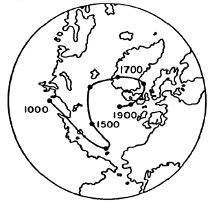
Our planet acts like a giant magnet. If this were not true, compasses would not work; they would not point to the magnetic north pole. Scientists have only a vague understanding of the cause of this magnetic field. But the great majority of them believe that it is probably caused by a gigantic iron core (called the "magnetic core") in the middle of the planet. It is generally agreed that part or all of this iron inner magnetic core is liquid. Both magnets and the earth itself have north and south poles. Unlike poles attract each other while like poles repel each other, thus the south, or north—seeking, pole of a compass needle is always drawn toward the north magnetic pole. (For purposes of simplification, we will generally speak only of the north pole in this study, even though there are two poles.) The center of the magnetic north pole gradually moves from place to place. At the present time it is centered in the Arctic in northern Siberia. This fact alone indicates that there is something unstable about earth's magnetic field, indicating a liquid core. Why should the magnetic north pole keep moving around? You might wonder how we can know that the magnetic poles move. We know it because rocks contain magnetic records of the past. APPARENT MOTION OF THE MAGNETIC NORTH POLE Paleomagnetic measurements of historic specimens, as well as direct measurements of particles and rocks, indicate that earth's geomagnetic core has gradually shifted somewhat over a period of time in the past. This fact would in no way provide any evidence favoring evolutionary theory. The axis of earth's molten core could easily shift here and there with the passing of time. The direct measurements were made in London; the indirect in a variety of locations, based on historic samples from c. A.D. 1000 through A.D. 1900. MAGNETIC PROPERTIES OF ROCKS—Most people do not realize that a large number of the rocks in the works have tiny magnets in them. These can be small iron particles within larger rocks. But lava, flowing out from volcanoes, cools into rocks containing tiny crystals of magnetite. At the time when that cooling of lava takes place, the iron magnetite becomes permanently magnetized in accordance with where the north pole was located at the time that the rock cooled! Achilles Delesse, a French physicist, in 1849 was the first to discover that such rocks were magnetized in parallel with the earth's magnetic field, as if the rocks were all recording compasses. This fact raised the possibility that earlier locations of the north pole could be ascertained. WANDERING EARTH OR WANDERING POLES-Then, in 1906 *Bernard Brunhes, another French physicist, made the startling discovery that some rocks are magnetically-oriented in exact opposition to the earth's field! Brunhes suggested that this might be caused by an earlier reversal in polarity of the global magnetic field. The new science of paleomagnetism (the study of the history of earth's magnetic field) did not really come into its own until the early 1950s, when the British physicist, Patrick *M.S. Blackett, invented a sensitive device called the astatic magnetometer. Using this apparatus, it was possible for the first time to detect the orientation of extremely weak magnetic fields—such as are found on tiny iron particles in rocks. Soon rocks were gathered up from all over the countryside and brought in for analysis with the astatic magnetometer. Variations were found, some of which may have been due to faulty collection methods, so clear results were not obtained. One rock would vary from another rock. Rocks can be kicked around, moved by tree roots, hurtled down hills by earth tremors or heavy rains. In addition, there is a very real problem of the extreme weakness of the magnetic field in rocks. It is so small that errors can be made in analyzing it. At first, scientists recognized this high margin of error factors inherent in using magnetic orientation to date rocks. But later in the 1960s and onward, they tended to ignore these weaknesses.
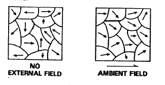
A related problem is that the magnetic particles in a given rock do not line up exactly the same. They generally point in one direction, but it is only something of a generalized pointing. All of these factors must be taken into consideration. AMBIENT FIELDS Below left., When magnetic rocks or particles point in every which direction, they exhibit no external field. Scientists say they have randomly oriented magnetic domains. Below right: But when ferromagnetic materials (particles or rocks containing magnetic ore) show a tendency to orient their directions somewhat, scientists try to estimate which way most of them, on the average, are pointing toward. They are then said to have an ambient field. They are said to have partially oriented magnetic domains.
THE CURIE TEMPERATURE—The minerals which exhibit magnetic properties are iron, nickel, cobalt, and their alloys. Rocks with magnetic particles will tend to be "ferromagnetic."An example of this would be a steel needle. It can be captured by a magnetic, yet will have no inherent magnetism. This is due to the fact that the iron in the needle is not aligned parallel in its magnetic direction. Other rocks can be "paramagnetic." Such rocks are like a permanent magnet; like the magnetized needle on a compass. Which types of rocks tend to be paramagnetic? It is those which (1) have magnetic mineral particles—especially iron,— and (2) which have been heated to a certain temperature and later cooled. This special temperature is called the Curie Temperature, and is usually between 400 and 600°C [752-1112°F]. For pure iron it is 770°C [1418°F], while for pure nickel it is 358°C [676.4°F]. Interestingly enough, these temperatures are well below the melting points of those metals (1535°C [2795°F] and 2732°C [4949.6°F], respectively).
There are a number of additional factors which weaken the reliability of using rocks to pinpoint earlier magnetic field positions. Here are some of them: The amount of magnetism in regular rocks is called "relative magnetic susceptibility." Of the various rocks, surface igneous rocks which have poured out through volcanoes and then hardened on the surface of the earth are the highest, for they have a rating of 10. They provide us with the best magnetic readings. Next comes subsurface igneous rocks with a rating of 8. Finally, comes granite with a rating of 51/x, Gneiss, schist, slate, with a rating of 2, and sedimentary rock with a rating of 1.9. 1- Volcanic rock. Thus, surface lava has the highest magnetic rate of any rock, and provides with us with best substantiated evidence of magnetic trends in the past. Igneous rocks normally contain a much higher percentage of ferromagnetic elements (iron, copper, and nicked than do the other rocks. Another factor which complicates the picture somewhat is that of "secondary magnetization." A rock that has been moved from its original position can later, over a period of time, acquire a secondary magnetic orientation. However, rocks with "natural remanent magnetism" tend to keep their original magnetic orientation. How and when did such permanent magnetic orientation occur in these volcanic rock? As the lava, fresh out of a volcano, cools from a hot (1000°C [1832°F]), molten condition, it solidifies at approximately 800°C (1472°F), and then continues to cool. As that rock passed through the Curie Temperature (400-600°C [752-1112°F]), its metal particles freeze into an orientation parallel with that of the magnetic core field of the planet at that time. It has acquired natural remanent magnetism. 2 - Sedimentary rock. Sediments and gravel are also analyzed for their alignment. When they fall through a lake, they tend to land on the bottom in a position parallel with earth's magnetic field at that time. Scientists call this "atepasitional" or "debital remanent magnetization." Paleomagnetologists value these findings also, but they are less reliable. Many things, including bottom feeders (fish, crayfish, worms, frogs, etc.), can shove those sediments around. As mentioned earlier, sediments also contain a smaller amount. of inherent magnetism, so their field is far weaker than that of lava. A serious problem is that rocks and sediments in stream beds have been found to magnetically align with the direction of the water current, which, of course, has nothing to do with the north pole. In spite of these problems, some scientists like to think that lake and ocean bottoms are relatively "quiet" and free from currents and disturbance by animal life. But evidence indicates both concepts are incorrect. 3 - Metamorphic rock. Metamorphic rocks are not used for purposes of analyzing earlier changes in earth's magnetic core, due to the fact that intense pressure can change the magnetism of a rock. You may recall that we briefly discussed this fact in chapter 7, Dating Methods.
4 - More reliability problems. In contrast with the magnetic instability of "depositional remanent" rocks, are the "thermoramenant" rocks, which were magnetized by coding. This is the lava extruded from volcanoes. Because of the heat factor, within a few weeks they tended to have their magnetic orientation frozen in place. If those rocks are not later moved, do not undergo pressure, high temperature, lightning strikes, etc., they may give a fairly accurate picture of earth's magnetic field at the time they poured out of a volcano and cooled. Thus we can see there are a variety of factors and possible problems which need to be kept in mind. Many rocks have what is known as "anistropoic magnetic properties." Rocks having this quality are relatively easy to magnetize—or rcmagnetize.
Magnetic storms caused by earth's gravitational field interacting with sunspot radiations can also result in changes in rock magnetization in a local area or over far wider regions:
Seasonal variations in the strength of earth's magnetic field (the GMF) can also lessen or increase rock remagnetization.
Two other problems are lightning strikes and the phenomenon called "self-reversal. " Lightning striking a rock can instantly reverse its polarity. It is known that, at any given time, there are more than 2,000 lightning storms taking place on our planet. Within a period of just one week, that is a lot of storms and a lot of lightning. "Self-reversal rock" is even stranger. At the time when volcanic rode is cooling, it is known that it can suddenly reverse polarity!
A fundamental difficulty is that it is impossible to know the temperature of a given rock in past ages, and whether it has changed in any way physically, chemically, or positionally. Thus we see that there are a number of events that can suddenly change the magnetization of a rock. It Is not a simple task to figure out "paleomagnetism," which is the study of earth's magnetic field in earlier times. It clearly is NOT an exact science.
One might imagine that earth's magnetic core would be an extremely stable arrangement, but did you know that there are indications that magnetic storms (induced by electromagnetic radiation from sunspots) causes earth's magnetic core to quiver slightly?
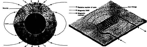
If solar storms can thus affect earth's magnetic core, think of the shaking power of the Flood on that core—when earth's surface broke open, water geysered out of its depths, ran down cracks into the interior, encountered molten rock, with resulting explosions and hundreds of volcanic eruptions! EARTH'S MAGNETIC FIELD Here are portrayed two views of our planet's geomagnetic field. On the left is the earth split open, with the north pole at the top and the south pole at the bottom. The magnetic core is shown darker in the center, with the lighter-colored mantle around it. On the right is a typical coil of wire with electricity running through it, producing a small magnetic field. The intensity of earth's magnetic field is strongest at the poles and weakest at the equator. The location of the magnetic poles change gradually over a period of time. At the present time, the field is inclined about 11 ° to the spin axis of the planet. Earth's magnetic field comprises about 90 percent of the magnetic field observed at ground level; the remainder is charged particles from the sun.
EARTH'S FLUID CORE—In addition to externally caused influences on earth's magnetic field, there are also causes within the earth itself. This includes the most powerful effect of all: actual reversals in the polarity of our planet! Evidence from cooled surface lava flows indicate that this has indeed occurred at earlier times.
A basic factor here is an underlying instability within the magnetic core of our planet. This instability is due to the fact that, as mentioned in the above quotation, a major part—if not all—of the core is fluid in nature.
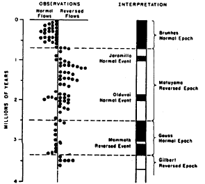
MOVEMENT OF THE POLES—One result of this instability is a gradual movement of the poles. The north axis of the field gradually swings from one location to another in the Arctic. The extent of the variation is as much as 30 degrees from the modern position of the north magnetic pole. On the basis of this evidence indicating polar drift, one researcher concluded that the cause was not polar drift—but continental drift. He decided that the idea of continents moving large distances horizontally was a simpler solution. Another research team, working on the same problem, concluded that the evidence pointed to s moving of the magnetic pole, not to a moving of the continents. In reality, the fault lies with an instability of the magnetic core within the earth; it is not necessary to imagine immense horizontal movements of the continental The route of this movement has been plotted. The magnetic north pole has taken a 13,000mile [20,920.9 mil path that began in western North America, curved across the northern Pacific and northern Asia, and finally reached its present position in the Arctic in northern Siberia. MAGNETIC REVERSALS—Is it possible that the magnetic poles of our planet have actually reversed themselves In the pass? We have two Issues here: (1) Have the poles reversed themselves? and (2) If they did, when did these polar reversals occur? There are respected creationists who contend that the poles have not reversed themselves, but rather that the only activity has been the movement of the poles in a generally circular motion around the geographical north pole. Their position may be correct. Actually, it is difficult to work with the available data and have certainty as to what actually occurred. In regard to the scientific evidence which is available, we do well to keep in mind that certain evolutionists in the past (such as *Haeckel with recapitulation, *Dawson with Piltdown Man, and *Darrow at the Scopes Trial) have shown themselves very willing to falsify data in an effort to prove evolutionary theory. We today cannot but be struck by the fact that evolutionary scientists can testify under oath in court that they know of no evidence favoring creationism) Can such men be relied on to provide us with accurate, objective research data, when it is in their power to tilt the scales a little? However, in this present chapter we will assume that there have indeed been reversals in earth's magnetic core—and we will explain how it could have occurred in terms of Flood geology. MAJOR GEOMAGNETIC REVERSALS Nearly 100 volcanic formations on several continents in both hemispheres were analyzed for their average ambient direction; that is, the direction toward which their magnetic lava most frequently pointed. On this basis, it appeared dear that there were four major geomagnetic reversals at some unknown time in the past. These four major, periods were termed "polarity epochs," during which time the field was predominantly of one polarity. Within them were shorter-length reversals, which were called "polarity events." Then, superimposed on as this, were dates in the millions of years, arbitrarily borrowed from the 19th century rock strata dating theory! Yet all of these reversals of earth's magnetic core could easily have occurred over that small period during and after the Flood when so many underground upheavals, collapses, and explosions occurred. THE NATURE OF THE CORE—Below earth's crust is a firmer layer called the mantle. Below that we eventually come to the core. Since much of the rock below us is molten, it is assumed that the heavier elements—especially iron—would go to the bottom. At any rate, there would have to be some kind of magnetic mineral down in the center to produce our planet's electromagnetic field. It would have to include a great mass of iron, acting like a gigantic magnet, producing our geomagnetic field. Most scientists consider all of the core to be liquid, but some think that only the top part of the core is. With part or all of the core liquid, it would be subject to instabilities due to vibrations. Some believe that only the top part of the core would need to vibrate in order to produce a reversal.
THE EFFECT OF REVERSALS—In addition to a magnetization of rock particles, so that their poles have been reversed, what other effects would a global electromagnetic reversal produce? Humphreys explains it:
*Grant Dalrymple, a scientist at the U.S. Geological Survey, led out in the 1960s in collecting and studying large amounts of rock from various places in the world.
At the present time, it is generally thought that there have been nine major reversals and a varying number of smaller ones. Data based on rocks gathered here and there are not very reliable. We have already teamed chat. Storms, currents, flash floods, sunspots, magnetic storms, pressure, heat, various movements of the rocks by animals, people, water, landslides, etc., and many other factors can Influence the magnetic bearing of those rocks. However, In this chapter we will assume chat the volcanic lava flows provide fairly reliable data. Whether or not that assumption is correct, we can have no certainty. For additional information, see the quotation supplement, "2 - Magnetic Reversals," in the appendix. DATING THE REVERSALS WITH POTASSIUM-ARGON—Although reversals may have occurred, we can place absolutely no confidence in the methods currently used to date those reversals! Underline that fact. Consistently, the methods of choice have been radioactive dating techniques. In chapter 7, Dating Methods, we teamed how notoriously inaccurate such methods are! So many unreliability factors are involved, that those methods are little more than a laughingstock. Among the very worst of these dating methods is potassium argon (K-Ar). —And now we discover that the primary method used to date magnetic rocks both on land and sediments in the ocean bottom—is potassium-argon! Potassium-argon is far worse than even the totally unreliable uranium/thorium dating methods! Here are several of the serious problems involved in trying to date anything by potassium-argon: (1) The radioactive decay rates for potassium are not clear; there is too much variation. You cannot date by a clock when it cannot keep time! (2) As radioactive potassium decays, it produces argon. Argon is a rare gas and quickly escapes into the air. Yet the experts try to date a rock in accordance with the ratio of potassium and argon remaining in it!
Astoundingly enough, in attempting to date those possibly-reversed rocks and ocean sediments—the test results of the useless potassium-argon technique are then compared with an imaginary dating method, that of rock strata dating! This is the theoretical geologic column dating method invented in the 19th century, also called stratigraphic dating. A theory was conceived by which fossils and sedimentary levels were arbitrarily dated at so many millions of years each, and then the solemn declaration was made that "index fossils" (tiny undatable marine creatures) had done the dating! Only those test results from potassium-argon dating which agree with stratigraphic theory are used; the rest are tossed out. THAT is how magnetically reversed rocks and sediments are dated! We have here the blind walking with the blind, leading the blind. Useless dating methods combine to fool the gullible, and the results are called the "advance of science." So when you read that so many millions of years ago a certain magnetic polar reversal occurred, know that the date came from a combination of potassium-argon and stratigraphic dating.
The dating of ocean core samples is done by comparing test results with stratigraphically-dated land samples:
Lava rocks formed in 1801 near Hualalei, Hawaii, were potassium-argon dated at 160 to 3 billion years. For more information on this, see Journal of Geophysical Research, July 15, 1968.
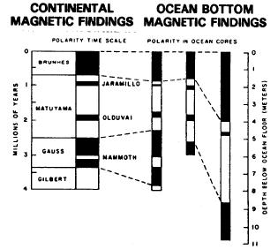
For additional information, see the quotation supplement; " 3 - Potassium Argon Dating, " in the appendix. OCEAN FLOOR EVIDENCE—In the mid-1950s, a U.S. government research ship surveyed 280,000 square miles of ocean floor off the coast of Oregon, Washington, British Columbia, and the Yukon Territory. The ship towed a "mag-fish" behind it; a torpedo-shaped metal box which collected data on various magnetic intensities of the ocean floor beneath. Scientism analyzed this data, and found it to be zebra-stripped in arrangement. Later surveys revealed similar magnetic patterns in adjacent areas of the Pacific. In 1962, the same type of ocean-floor zebra patterns were found in the Indian Ocean. "Continental drift" advocates theorized that the stripped patterns were caused by magnetic reversals during "seafloor spreading" which pushed the continents apart. But the magnetic stripes may have been caused by variations in magnetic intensity, instead of changes in direction (reversals). Keep in mind that the researchers have assumed that reversals would bring a change in magnetic strength, with the stripes therefore indicating reversals. But those stripes may not actually be evidence of reversals! To this day, we cannot know whether the cause of the zebra markings were changes in magnetic intensity or changes in magnetic direction. We will here assume reversals, but that may not be the cause. It would be well to keep in mind that, in regard to ocean floor evidence, we are primarily discussing sediments. Earlier in this chapter we discussed a number of factors which would greatly weaken confidence in paleomagnetic conclusions based on studies of sedimentation. ("4 -Ocean Core Dating" at the end of this chapter, is a powerful refutation of the validity of ocean sediment magnetic analysis.) LAND/OCEAN BOTTOM MAGNETIC CORRELATIONS Not only on land, but in the ocean bottoms is there great confusion in regard to magnetic polarity. However, in spite of all the problems, desperate attempts have been made to arrive at some kind of standard pattern for ocean core magnetic sediments. But somehow the results had to be wrested into conformity with continental-land-geomagnetic patterns. Those, in turn, had to be pressed into agreement with the notoriously-flawed fossil strata dating theories! The outcome of it as is shown on the chart below. On the left are the land magnetic scales, and on the right, the ocean-core magnetic conclusions.
A landmark meeting convened in 1964 in London. The *British Royal Society had sponsored a "Continental Drift Symposium." At this meeting, *Edward Bollard showed a map of the Atlantic continents as they earlier had presumably been joined together. That "scientific evidence" settled the matter in many minds. The following year, a *National Science Foundation research ship plotted more than a thousand miles of stripes on the ocean floor. At the April 1966 meeting of the *American Geophysical Union, slides of these stripes were shown, and the audience was told that it was "evidence of reversals," and therefore of seafloor spreading. More were convinced. Then it was noted that the stripes went outward from fracture zones—that had volcanic activity within them. These oceanic fault lines were given the name, "transform faults." Surely, this was the final evidence needed to prove seafloor spreading. But still another "evidence" was forthcoming: Scientists learned that shaking movements had occurred in these faults, so it was decided that only seafloor spreading could cause those earthquakes. (Because earthquakes occur at faults, that indicates sea-floor spreading?) The 1967 meeting of the *American Geophysical Union was taken by storm by the enthusiastic advocates of seafloor spreading, continental drift, and plate tectonics. The primary evidence was core samples taken in the Pacific. The core samples showed evidence of alternate strong/weak magnetic patterns, which were interpreted as evidence of reversals. (See "Ocean Core Dating," later in this chapter.) The core samples were dated by a combination of potassium-argon dating, plus assumed seafloor spreading rates:
Then, in September 1968, three enthusiastic supporters of the new theory announced "still stronger evidence": They had found that earthquakes are less powerful at a distance from the "plate edges", and stronger near them. (That is evidence? We always knew that earthquakes tend to center at faun lines.) Additional research shortly after that revealed that most of the earthquakes definitely do occur in the areas where the plate edges are located. Finally, in 1972 and 1974, scientists found small amounts of lava flowing from a crack in middle of the Atlantic Ocean. That was considered even greater evidence! (Would not lava be expected to flow out of cracks in the earth?) For additional information, see the quotation supplement, "4 - Core Dating, " in the appendix. Before analyzing the evidence in regard to the ocean flow, let us briefly summarize the volcanic findings: VOLCANIC EVIDENCE —Research studies were made of nearly 100 volcanoes in both North and South America. It was found that about 50 percent of the flows from these volcanoes were reversed in polarity from what earth's magnetic core now has. We earlier mentioned that there is indication of there having been 171 reversals. This volcanic study revealed only four primary clusters of reversals. WHAT IS THE MEANING OP THE EVIDENCE?—We shall here interpret this evidence produced in defense of the new theory In light of Flood geology. In the process we shall learn that the evidence nicely dovetails with Flood geology! The Flood was the greatest physical crisis our planet has ever undergone. There has never been anything like it. After the earth, and all that is in it was created in the six literal days of Creation Week, the world continued on peacefully for nearly 1700 years. Then, at the command of God, Noah entered the Ark. The last look outside was probably long remembered, for the world would never be the same again. Seven days after that door was shut, a tremendous upheaval began. The immense vapor canopy in the skies poured down upon the ground. The earth shuddered as massive jets of water poured up from the bowels of the earth. Massive rocks were heaved up into the air. Great holes were gouged out of the ground. Large fissures and cracks appeared. The subterranean water system was being emptied out. The earth itself was rent and torn as a result. But then the water ran down those cracks and made contact with the molten rock below. Immense explosions occurred; the earth shook to its very heart under the impact of hundreds of explosions rivaling that of Krakatoa in 1883, when water from the Indian Ocean went down one (just one) rent hole—and caused one of the two greatest explosions in modern history (the other one was the explosion of Mount Tambora in 1815 near Java). Under the impact of all this, the liquid core itself shook, and the poles reversed themselves a number of times. Polar reversals may seem astonishing to us today, but it would be a simple event for earth's liquid magnetic core; all that would be required would ix the kind of conditions occurring at the time of the Flood. Intense shock waves sent down from those massive multi-explosions could easily cause the reversals. Keep in mind that the earth was so tom up at that time, that the subterranean explosions could occur very deep Within the ground. Volcanic explosions today take place relatively close to earth's surface, and lack the power and proximity to send similar reverberations down to the magnetic core. A little shaking of the liquid core was all that was needed, and it happened a number of times. Reversals continued to occur. In between the reversals, geologic history was being made. Immense layers of sediments were being laid down, land was draining, oceans were filling, volcanoes were exploding, mountains were rising, strata was crumpling and folding, continents were rising.
Volcanoes would spew out their lava. Cooling, it would freeze its paramagnetism solidly in line with the poles and the magnetic orientation just then in place. A number of reversals occurred, for hundreds of volcanoes were erupting at the time and several major surface and below-ground explosions could be expected to have taken place. The effects were dutifully recorded as fresh lava flowed out and hardened into magnetic patterns, toward the north, then toward the south, and back again. It is of interest that lava from two nearby volcanoes in Japan each have different polarities, even though their flow fields are both on the surface! Such evidence violates the evolutionary theory of long ages between each reversal! Instead, only an obviously short time could have elapsed between one reversal and the other. Yes, there were reversals, but they occurred close together—not over a period of long ages.
*J.A. Jacobs recognized that it would be impossible for surface laves to have two different polarities—if reversals only occur millions of years apart!
Humphreys later explains that different polarities have been found in strata from a single volcano. (See chapter appendix, " 2 -Magnetic Reversals.") Thousands of extinct volcanoes are to be found all over the world today. At the time of the Flood they were spewing forth the results of those underground explosions. Overhead, the sky darkened and the ice age was the result. Beneath the surface, the vibrations from those explosions went downward and shook the liquid core some more. Consider this: it is of interest that the great majority of all extinct and live volcanoes and earthquake epicenters are located in oceans or on land within 100 miles from an ocean. Justas in the time of the Flood: it may well be that it is the coming in contact of water with molten rock that produces a major share of the underground violence, resulting in the largest volcanic eruptions and the biggest earthquakes. Lateral vents, as well as vertical ones, can let ocean water enter cracks and cause explosions such as occurred at Mount St. Helens. Before the seas sank and the continents raised, volcanic activity in the "subduction faults," produced out-flowing volcanic lava. Cooling as it went, it would register the latest magnetic reversals. The magnetic imprint was recorded in stripes. It was the lava that was spreading, not the seafloor. Then the oceans began filling. We today know of other volcanoes in the oceans. Scientists call them sea mounts or guyots. Although hundreds of feet below the ocean's surface, their flattened tops reveal that the ocean was earlier much lower and gradually filling. These thousands of flat-top, extinct volcanoes stand as mute evidence to a world in transition during the Flood when the oceans were rising. Gradually the oceans filled, separating continents that once were closely linked together, with similar vegetation and minerals. Why do some of the continents appear to "fit together?" Because they were once joined or nearly joined, and when the Flood came, it sent mighty streams down between them that carved out great rivers separating them. As these widened into massive seas, the outline similarities between the continents remained. Does the above Flood model answer all the questions about paleomagnetism? It answers a remarkable number of them. Does evolutionary theory answer as many? No, it does not. QUESTIONS ANSWERED—(1) Why would the continents literally move sideways? Continents do not move sideways thousands of miles! The term, "continental drift" is a euphonym to cover over a hard fact: continents, weighing trillions times trillions times trillions of tons simply do not move horizontally long distances. Just because a scientist theorizes that it happens does not make "plate tectonics" any more true, than their theory of "thrust faults," which teaches that a number of the large mountains on the globe moved there from somewhere else, yet did so while never disturbing fragile and unstable rocks within them and below them. (See chapter 17, Fossils and Strata.) Plate tectonics theory teaches that places of flat rock, some half a world wide, are continually moving sideways. They are so strong that they can do this, even though supporting the weight of oceans and continents! Then, at their edges they ought to CRASH into one another! But this they do not do. The theory conveniently has one slipping relatively quietly under another! The plate is hard and strong and thick enough to support oceans and continents, yet upon meeting another plate, it is said to BEND and move beneath it. Where does it then go after that? The plate is said to conveniently drop down into the liquid magma of molten rock beneath. Well, then, if a plate is constantly moving under other plate, where is the fresh new plate at the other end coming from? Oh, it comes up out of that molten rock, becomes solid, strong, hardened plate, then bends sideways to slip out from beneath the plate above, and thereafter is flat and straight as it moves along holding up the weight of oceans and continents, until it meets another plate—and then it courteously bends downward rapidly into a 90° angle (1) and goes under again.! The angle of bend is so sharp that no gap is made in the earth's surface! Seriously, now, is that scientific? It recalls to mind the science fiction stories we encountered in the first chapter when we discussed the Big Bang theory. And what is the mechanism that pushes soupy liquid rock upward and then carefully laminates it into sturdy sheep, which are able to both bend at sharp angles under plates, yet be unbendable under continental masses and the immense weight of oceans? We are told that it is 'convention currents,' the circular motion seen in water boiling in a pan. But hundred-mile thick rock is not water! (2) But are not "transform faults"—earthquake and volcanic cracks in the oceans—proof of "seafloor spreading"? No proof at all. Are volcanoes on land any proof of "landfloor spreading"? None at all. Is the San Andreas Earthquake Fault in California spreading sideways? No, it is not. (3) But are not the earthquake/volcanic faults that ring the Pacific, and run through the Mediterranean and elsewhere-proof of the existence of the tectonic plates? No proof at all. The faults merely indicate weak places in the earth's surface, through which volcanoes vent. These are cracks. Water going down those holes cause explosions, and earthquakes and volcanoes are the result. Indeed, there are many volcanoes which are located at a great distance from any theoretical tectonic plate termination. Earthquake epicenters occur in areas far from the edge of the imaginary plates. (4) But what about the core samples which revealed that the lava nearest the "transform fault" volcanoes was the youngest? That is right; it was. Would you not expect the rock and lava nearest Mount St. Helens to be younger (more recently spewed out of the earth) than materials farther from it? That is the way it is in the oceans also. But because the lava closer to Mount St. Helens is younger than lava farther away, is no evidence that the North American continent is moving sideways away from Mount St. Helens! (5) If there were volcanoes at the time of the Flood in the "transform faults, " then why do we not see them all today? First, the ocean decapitated the tops of the sea mount (guyot) volcanoes as they rose. Would we not expect that the ocean would totally eradicate many brand new volcanoes when it first began rising? Second, keep in mind that many of those volcanoes blew themselves to pieces just as Krakatoa did—and there is little remaining of them today. (6) Why are there more earthquakes, and more powerful ones, where the edges of the plates are located? It is not news that there are major earthquake faults in the world, nor that earthquakes and volcanic action is closely associated. We would expect the largest crocks to produce the most earthquakes and the most powerful ones. The fact that they do this is not an evidence that moving plates travel for centuries as they hold up the weight of miles of soil, rock, and water—and then relatively gently roll beneath another plate! Somewhere in the works there ought to be two plates that are less courteous—and produce an age-long crashing together that thrusts cracked pieces of plate, miles thick and even more miles long—high up into the air. These "plates" would to be far larger than any land feature anywhere in the world. It ought to be like large sheets of ice when they collide. Crashing together, they ought to produce mountainous upthrusts that reach at least to 80,000 to 100,000 feet [243,84004,800 dm] in the air. The evolutionists tell us the plates have been hitting together for millions of years. Evolutionists tell us that the Himalayas are the largest example of plates cracking together. But the sheer size of the global plates is such that continuing, million-year head-long collisions between two such massively thick sheets-could not possibly result in such small mountain ranges as the Himalayas. Interestingly enough, there is no distinctive faultline collision zone apparent in the Himalayas nor in any other mountain range. Instead, we find a jumble of mountains, caused either by folding or volcanic action. (7) But what about the fact that scientists have found fossils In the oceans, and some are younger than others? They claim that this proves "sea floor spreading." Fossils are "younger" and "older" only if we accept the evolutionary fossil strata theory. There are so-called "younger" and "older" fossils in mountains, but that does not prove they are younger or older, nor does it prove "mountain spreading." (8) But do not those fossils In the ocean floor prove something evolutionary? They prove nothing evolutionary at all. In fact, they witness instead to Flood geology. Scientists have frequently tried to produce fossils by dropping dead bodies of fish and other creatures into lakes and oceans. Yet they have found that no fossils are produced. Yes, fossils have been found at the bottom of the ocean, below the top sediments. But those fossils could only have been made when the ocean was not full of water! Fossils are not being made today in the oceans. For additional information, see the quotation supplement, "4 - Ocean Core Dating," in the appendix. CONCLUSION—How do we relate to all this? The entire field of study is relatively new. 1 - Paleomagnetism. You will note that the paleomagnetic evidence for rocks, lava, and sediments is quite uncertain. It is clear that a percentage of the data is probably in error. The mechanism driving the plates is missing. The credibility of it all working in the way described is fantastic. The evidence that circular plate tectonic motion is occurring does not exist. 2 - Magnetic reversals. In this chapter, we have chosen to assume that there is evidence of geomagnetic reversals. But, having assumed it, we find that the assumed events would be quite nicely predicted by events that occurred during the Flood. But even that does not prove that the reversals occurred. The questions are not all answered; perhaps they never will be.
The following sentence is important and summarizes the situation well:
You have just completed Chapter
26 Paleomagnetism
|